MARIN MUNICIPAL WATER DISTRICT: A Breathtaking (& Ankle-Busting) Hike Up Pine Mountain on a Dramatic Day in the Heart of the Mount Tamalpais Watershed
.jpg)
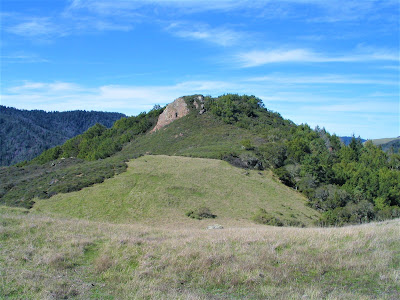
Situated on a rock-strewn promontory blanketed with a dense forest of bonsai-like Sargent Cypress, stunted manzanita trees, and mixed chaparral growth, I gaze out from my wind-protected perch.
.jpg)
Christened "Fort Repack" by local legendary mountain bikers, I am afforded a view of a wild landscape of cleaved and rolling hills, and to the southeast I gawk at the 2571 ft. landmark peak of Mount Tamalpais beyond the gullied tributaries of Cascade and San Anselmo Creeks' upper headwaters.
.jpg)
Suddenly my transfixed attention on that surreal scene of mountain floating in clouds is diverted by the spectacle of a Northern Harrier – identifiable by its heft, large wingspan and characteristic band of white across its rump.
.jpg)
He's fighting off a kamikaze onslaught of ravens tormenting the raptor in her low-flying mission to round up a tasty meal . . . or perhaps they're only engaging in a bit of roistering avian antics?
.jpg)
Lots of swooping, circling, darting in and out, and screeches and cawing.
.jpg)
Finally, the ravens band together and fly off, leaving the hunter bird in peace, and now she glides smoothly, no more than ten feet over a hillock, wings fully extended, orange talons unclenched, and makes an amazing dip and stab downward to bring up and fly away with a small helpless rodent.
.jpg)
First time I've ever seen a Northern Harrier, and what better place to spot one of these beauties than in the skies of Pine Mountain – home and hearth to dozens of unique plant and animal species well adapted to its local serpentine soil and pristine ecology.
.jpg)
Flanking the northwest slopes of Mount Tamalpais, the 1762 ft. eminence (it really lacks a peak, per se) and surrounding purlieus provide incredible recreational outings whether by foot or by bike – remember, this area is the birthplace of mountain biking!
.jpg)
Granted, you can cover much more ground by two-wheeled travel – up to 20+ mile loops – but hoofin' it can also take you to intimate places mountain bikers will forever miss, as well as get you to remote spots with spectacular views you're not likely to find anywhere in the vicinity, except at the top of the great mountain.
.jpg)
Starting the day at the staging area off Bolinas–Fairfax Road at Azalea Hill outside the town of Fairfax, you begin hiking up the rutty, rocky fire road that immediately taxes you.
.jpg)
It relentlessly climbs upwards of 400 ft. to the juncture of Oat Hill Road, passing gorgeous rock outcrops richly textured with serpentine colorations and opening up to tremendous views of the entire Bay and beyond to the distant yet imposing triangular massif of Mount Diablo looming nearly thirty miles away.
.jpg)
At Oat Hill Road, you can turn left, and check out the gorge of Carson Falls or keep hiking up to the juncture of San Geronimo Ridge Road and Pine Mountain Road, where you can continue your trek for more than ten miles to complete a loop in either direction.
.jpg)
Or you can hang a right and head down Cascade Canyon (or Repack) Road for unlimited exploration and adventure in Camp Tamarancho – mountain bikers' single-track paradise – and the eco-preserves of Cascade Canyon and White Hill Open Space Districts.
.jpg)
Whichever way you choose to go – whether you're on foot or bike – pace yourself because the miles do not come easily in this big, rolling, rugged land.
.jpg)
Also, be sure to take plenty of time to stop and take it all in, for there's lots to be missed if you're hurrying along to make time or knock out big miles, or not paying attention.
.jpg)
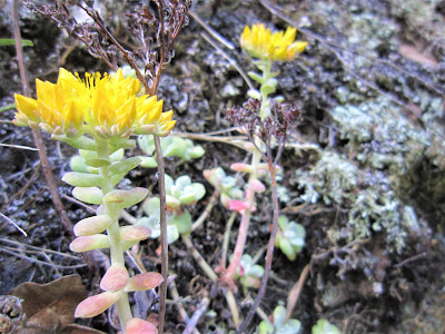
I've espied a half-hidden bobcat licking herself on a rock, an elusive coyote hunting for mice, shy deer seeking refuge in a glade, camouflaged snakes, newts, raccoons, and the occasional fox, along with (in season) gorgeous displays of native wildflowers.
.jpg)
Whether you cover twenty miles by bike or five miles by foot, it's imperative to take time (make time) to absorb every little and big sight, every subtle and overpowering smell, every imperceptible sound of nature all around you.
.jpg)
Otherwise, you're just competing against yourself, and missing the nuances of the natural world. Why, if you have a mind to, or feelin' a lazy streak comin' on during a leisurely outing.
Even if but for a day, Thoreau implored, let idleness be your:
" . . . most attractive and productive industry."
.jpg)
Who needs to cover all those miles anyway?
You do, of course. They're there for the walking, the clicking off on your mental pedometer, for here, in this empyrean place, Thoreau also noted, "heaven is under your feet" as well as above you.
.jpg)
So, you summit Pine Mountain, take in sweeping 360-degree views of big weather patterns, then return to have a leisurely lunch at Fort Repack, whose rock walls shelter you from whipping zephyrs.
.jpg)
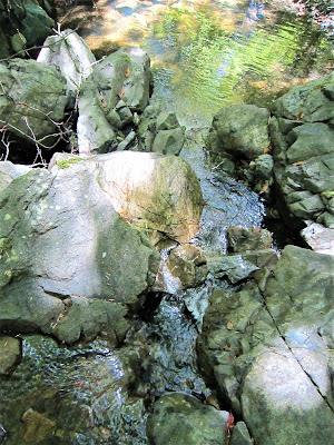
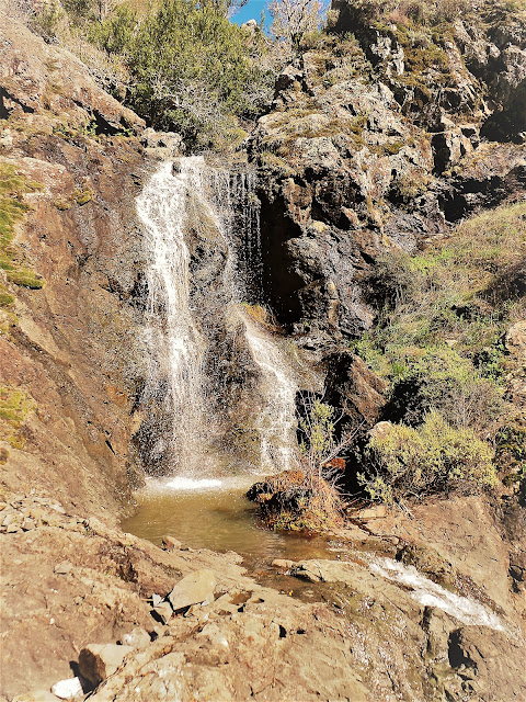
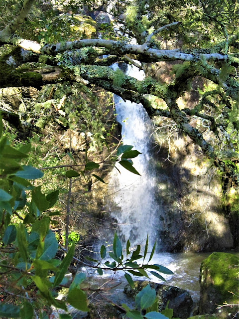
Afterwards, stomach sated, feeling adventurous, and thirsting for the soul-replenishing drama of a waterfall, you head down an off-beat path – trod perhaps only by deer and foolhardy humans – to stumble upon Carson Falls, a beautiful tumbling series of cascades fed by Little Carson Creek.
.jpg)
What precious little rain has fallen has rejuvenated the flow, and it's a sight to behold – magical water, emanating from on high in mysterious drainages never to know or discover, gaining momentum from humble beginnings as a snaky little ribbon of stream.
.jpg)
Then, ever so gradually, losing elevation, to greet a lip of carved rock and pour forth its discharge in a roaring blanket of white water, then, ever so alluringly, dropping into a series of plunge pools, chutes, twists and turns maybe 150 ft. to its base where it continues, ever so beautifully, to flow free falling 500 feet and seven-tenths of a mile.
.jpg)
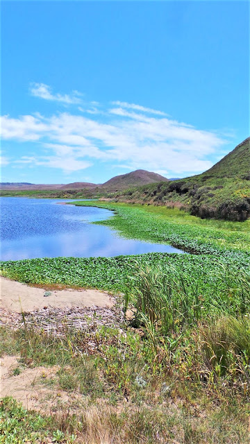
Continuing its journey through a beautiful, forested ravine, in an ever-increasing rush of swirling water, until Kent Lake – the largest of the watersheds' three reservoirs – halts its journey and swallows it up.
.jpg)
Carson Falls is super-popular with waterfall lovers – rightfully so! – who are not always careful (along with their dogs) to avoid trampling the breeding grounds in and along the riffles at the pool sides, where the endangered foothill yellow-legged frog lays masses of gelatinous eggs.
.jpg)
Once commonly found throughout Marin County streams, the habitat of this "species of concern" has drastically shrunken and degraded and is now protected mainly in and around Lagunitas Creek and tributaries such as Little and Big Carson Creeks.
.jpg)
Unfortunately, elsewhere in Oregon and California, due to insidious human activity – the creation of dams altering water flow, logging and livestock grazing practices, pesticide usage, and the introduction of non-native predators like bullfrogs has all but been wiped out.
.jpg)
(Hikers, please pay attention to the posted signs warning of the frogs' sensitive presence.)
.jpg)
And so, whether sunning idly on a warm rock overlooking the falls, or taking in idyllic views from higher up, it's a dramatic day of big weather – puffy white clouds and blue skies, alternating with tenebrous conditions blotting out the sun, and producing a dryish rain and a few seconds of bombarding hail, and always those pay-off long distance views.
.jpg)
Yes, it all makes sense now why you live in the Bay Area, why you put up with the stress, the crowds, the never-ending hassles of urban living . . . all so you can escape it under an hour and find paradise in your backyard.
.jpg)
Even before a time when we think of the rat-race, John Muir pointed out long ago:
.jpg)
" . . . thousands of tired, nerve-shaken, over-civilized people are beginning to find out that going to the mountain is going home; that wildness is necessity; that mountain parks and reservations are useful not only as fountains of timber and irrigating rivers, but as fountains of life.”
.jpg)
AMEN!
.jpg)
PRAISE BE!
Read more Gambolin' Man write-ups about incredible, fabulous, amazing Marin County:
Read more posts from Gambolin' Man on Marin County's incomparable and magnificent Point Reyes National Seashore:
Take a moment to enjoy some live-action scenes taken in Marin County's Municipal Water District lands & various other stunningly beautiful Marin County locales @
posted by Gambolin' Man at Sunday, February 15, 2009
0 comments
![]()

