HENRY COE STATE PARK: Takin' it to the Edge of the Orestimba Wilderness
.jpg)
I was eager as hell to ride out the rollicking Kaiser-Aetna Road, starting from the bottommost and least visited entrance to Henry Coe State Park.
.jpg)
Ever since the Spring of 1996 (already!), when Mary and I had an opportunity to drive (yes, drive) to the Orestimba Corral, through this great green expanse of rugged hills, I have had a hankering to return.
.jpg)
That year, we were taking part in the park's annual "Backcountry Weekend" – a ludicrous affair of 300 lottery-chosen vehicles sweepin' up a ton of dust on the graded road 13 miles in.
.JPG)
Imagine over 500 people as eager as ourselves to get a chance to visit the remote wilderness area, all trying to disperse over 20,000 acres in a couple of days; but it was a regular ol' back country jamboree, as most people opted to set up tents and camp in the corral or right in the camper shells of their big vanity trucks.
.JPG)
Not exactly to our liking, so we were content to idyll away the day along the creek and in gullies, but now I regret not having had mountain bikes! It's the only real way to escape the crowds, explore places it'd otherwise take you days to get to and back.
.jpg)
We did hike far and long enough to get a taste of the Orestimba – one of a handful of California State Park wilderness designations – it's a pretty special place and I knew, someday, I'd get back there.
.JPG)
This little-used access point, known as Bell Station, (once a restaurant and hotel) is an undeveloped area off Highway 152, now "on the table" as a possible site for a huge hydro-construction project – a reservoir to "improve water quality" for Santa Clara and Silicon Valley.
.jpg)
Should the plot go forward, it would flood hundreds of acres of pristine wilderness habitat (as well as a pristine refuge for city-weary humans); if allowed to proceed, this special area would be rendered inaccessible.

Even barring this catastrophic development, State Park officials have Coe/Bell Station slated for future development to increase usage of this unknown, under-appreciated "staging area".
.jpg)
So, enjoy it while it lasts!
You have to recognize the massive volcanic plug to the south, upthrust millions of years ago from the seabed, called Lover's Leap, in order to know just when to cut left into the parking lot.
.jpg)
The sucker's an easy-to-miss and dangerous pullout with a very tough left-turn across vicious traffic screaming down from the Pacheco Pass into Hollister and Gilroy.
.jpg)
Luckily, it was 7 a.m. and Super Bowl Sunday, so I had the entire place to myself, all day long. Not a soul (except many animal souls whose paths crossed with mine!).
.jpg)
Yet someone else was out there, evidenced by a parked vehicle, no doubt a biker with probably twenty or thirty minutes on me tops. I never did catch up. Didn't matter, didn't want to catch up.
.JPG)
Today was going to be a rare day of soul-searching solitude, serene contemplation of the miraculous commonplace all around me of which I am an intimate part. Alone and away from the madding crowd where I can observe the wonders as they occur around me.
.jpg)
Had we gotten to Bell Station at the same time, or met on the trail a ways up, heaven forbid, we might have ended up having to ride together, and that, unthinkably, might have led to some new friendship or jubilant temporary camaraderie.
.jpg)
But no, the most I saw of the phantom biker was fresh tracks, one set only, then mine. I kept thinking I was going to catch his ass, but I never did. I did, however, frequently hallucinate voices the entire time!
.JPG)
Even saw a shadowy sylvan sprite or two out of the corner of a numb THC-drooping eye (it was cold!). And I was deep in, twenty miles back – what if my chain broke or it was my ankle?
.JPG)
But, whoa, let's not get ahead of ourselves here, besides none of that happened (but the thought nags you, haunts you, especially when you're alone, twenty miles in, and no help in sight for possibly days).
.JPG)
The fog-shrouded morning was cold, nearly dripping with mist; a mile in my feet were wet. I suited up, ran in place for a few seconds, blew on my hands.
God! I love this stuff!
I jogged over to read the signs about the geology, history and ecology of the area, then set my cyclo-computer and hoisted my bike over the barricade/fence and set off on the first six miles or so.
.jpg)
This back country road would take me by surprise so early in the morning – a torturous elevation gain in the first two miles of 900 feet, I'm guessing, through private ranch lands – an agreement with the park and the owner to allow respectful passage through to the park proper.
.jpg)
Finally, at Dowdy Ranch, around mile 7.3, no doubty about it, I was on the veritable fringes of the fabled Orestimba Wilderness! Who gets excited about the Orestimba Wilderness? The Ecoscenti?

Now, tell me, who do YOU know who's ever been to the Orestimba Wilderness, or even knows of it?
.jpg)
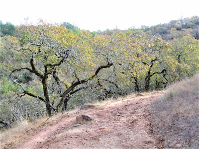
The ranch was nothing but a couple of ramshackle structures overlooking a long, blue view of valleys, ridges and forest expanding 180 degrees before me in undulating magnificence. Construction was going on – so it's for real, they are developing south Coe Park entrance for the multitudes.
.jpg)
Well, I just wanted to cruise on past Burra Burra and Walsh Peaks, Tie-Down and Rooster Comb, mythic sort of name places to me for some reason, probably for all the eye-squinting lucubration poring over the new Coe map recently.
Rooster Comb Loop is the longest through hike in the Bay Area at over 70 miles!
.jpg)
I've yet to do it! There is so, so much at Coe! The whole route was scenic with wondrously painted, whimsical, down-to-earth, beautiful geological formations! So unheralded, this landscape! which is totally fine by me; those are the best places!
.jpg)
Off I went screaming down a deadly two mile, 20 percent grade to Pacheco Creek crossing, at mile 9.1 – a perfect place to drop the bike, throw off helmet and gloves, take a break, find a perch near burbling water, eat a sandwich, sit in meditative reverie and marvel at this pretty little stretch of crick that'd do Thoreau proud.
.jpg)
There, I bent over to pet the greenest moss you ever did see.
.jpg)
There, I held in my hand delicate tangerine colored bay leaves and let them flutter to a gently swirling pool.
.jpg)
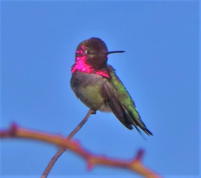
There, I heard sweet melodies of a myriad birds serenading me and coaxing out of my very being the best feelings of joy, peace, contentment that lie within.
.jpg)
There, I marveled at sycamore roots twisted and gnarled into cyclopean benches.
.jpg)
There, green mirthful hillsides infused me with a sense of infinite possibility and truth, don't ask me why!
.jpg)
There, a densely forested hill with dimensions of a steep-angled pyramid about 200 feet high!
.jpg)
There, in the company of oak bay madrone and yes pretty p'oak, I hugged and kissed and spoke to my tree friends.
.jpg)
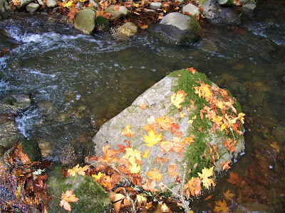
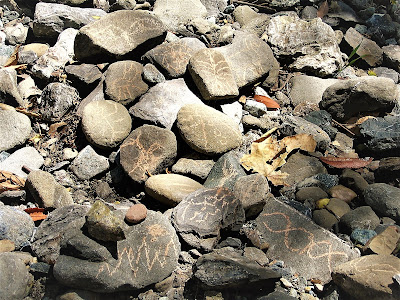
There, in little old Pacheco Creek, I deeply appreciated a miraculous flow of water coursing merrily over blue-green andesite rocks (so typical of Ohlone Country).
.jpg)
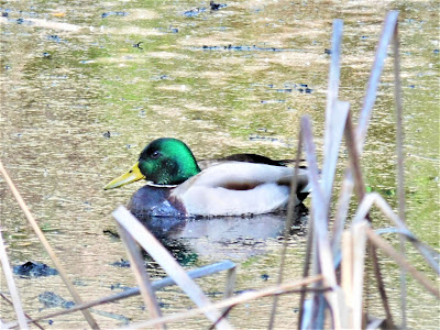
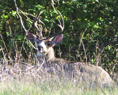
There, I waved at the deer that just leapt gracefully up the slope.
.jpg)
There, I wished a newt inching purposefully across a mudbank safekeeping for a good journey to wherever.
.jpg)
There, a chorus of funky frogs evoked sad childhood memories of shooting little dime-sized suckers into the sand by the dozens with my BB gun.
.jpg)
There, my rhythmic breathing became attuned to the organic pulsings of energy – life! – all around me! And knowing I'm alone, a vulnerable part of the animistic flow, makes the experience primal, archetypal, regressive to a life/reality we have lost, no longer know, no longer get to experience.
.jpg)
The Orestimba Corral was still about four miles down – make that UP! – the road. I didn't want to leave the creek and wasn't ready for the tough four miles it turned out to be! It's like ascending to another realm, climbing out of the creek valley to the Orestimba.
.jpg)
You really have to work and really have to wanna experience the Orestimba, to subject yourself to these rigors; for the miles at Henry Coe, I repeat, do not come easy.
.jpg)
At the crest, it's a blast zooming down past wildflower-strewn crags (never too early for blossoms at Henry Coe!), and then stopping for a full fifteen minutes in lush expansive forests to listen to a symphony of birdsong, then climbing up and up, another 1000 feet of elevation gain, to ascend to the higher plateau comprising the Orestimba Wilderness proper.
.jpg)
That would be, oh, about 20,000 acres worth of truly resplendent, untrammeled lands, draining the vast watershed of Robinson Peak. a part of Coe I have not been and don't anticipate exploring until/unless I hook up the panniers and ride out with camping gear for four days; even then, you have to ditch the bikes and set off on foot.
.jpg)
So, you see, you really gotta wanna make this happen to get out to where I was, 13.1 miles from the car, with wet feet from a dozen stream crossings; no, the miles at Henry Coe do not come easy, but they're the prettiest around!
"Hills of Deception" and "Devil's Hills" are web nicknames for this place!
.jpg)
Let me repeat that one more time: the miles at Henry Coe do not come easy (but they sure are pretty!).
Finally, I was at the Corral. Not much had changed, except this time I was alone. It was eerie with gray skies slung low, muted colors of a dull wintry day.
.jpg)
I needed something fun and cheery to do, so I rode the singletrack Orestimba Creek Trail for about two miles up and over the hill and back down to the winding creek. It was a rollicking good time, over too soon, so I decided to continue on to Paradise Flat and Paradise Lake, only another five miles or so away, previously just spots on a map I yearned to explore.
.jpg)
Turns out the first half was a tough challenging technical course as the trail became one with the creek bed. Chunky, clunky and bumpy, you had to bear down and stay your course. Many would have hated it.
But I tore that shit up. (HOLD ON! It tore ME up!)
.jpg)
Oh, on that beautiful stretch of the northeasterly (!) flowing Orestimba, stopping every so often to simply gaze in the gentle zen pools formed in its sinuous course through this vast, beautiful, green wilderness before eventually flowing out onto the flatlands near I-5 below Modesto, where, sadly, it becomes a heavily contaminated trickle.
.jpg)
Even though the day was still gloomy, and I was cold, wet and getting lonely (not really!), I was really enjoying the adventures and challenges of the day. Soon, hard trail picked up and before long the land had leveled out in all directions:
Paradise Flat!
The lake was off a spur trail, steeply downward, so I ditched my bike and walked there for a picnic. It was – I hate this usage! – FLAT OUT GORGEOUS! Another world unto its own: no, it ain't North Fork country, or the Siskiyous, nor is it the John Muir, but it is central Californian Diablo Range wild lands, stretching as far northward as Lake County, perhaps, and in the immediate Bay Area.
.jpg)
Mount Diablo is its central crowning gem, and farther down into the Ohlone-Sunol Regional Wilderness, Joseph D. Grant County Park, Henry Coe in south Santa Clara County; hell, probably Pinnacles National Park and portions of inner Los Padres National Forest are extensions of the Diablo Range.
.jpg)
In short, it's a wonderful, unpeopled place! And this time of year, when the water's flowing and the hillsides are green and wildflower-strewn, there ain't no place purtier in the entire world!
.jpg)
The Orestimba epitomizes this rugged, recondite world, where in the autumn of 1869, a hunter watched Bigfoot swinging lighted sticks from his fire, and a year later, in September 1870, Orias Timbers reports two hunters saw "gorillas". (An ingenious and somewhat purposefully obfuscating anagram of Orestimba!)
.jpg)
The sense of utter remoteness from all things urban and civilized still exists today. Ol' Sasq' is no doubt stompin' around out there somewhere this very second. (Wait! What was that? Could it be? Probably just a mountain lion.)
Back to Paradise Lake, though; that place blew my mind – a supremely isolated body of placid, darkened water backed on all sides by gigantic green mounds of earth. If only old Sol were shining down to reveal this magical place in its full sun-soaked glory! And warm my bones up a bit too!
.jpg)
At one point, as the clouds brightened perceptibly for a few minutes, I yelled out, Let there be light! But it never broke through. By now I was pretty cold and couldn't afford to sit around lounging and enjoying it all in my usual stupefied state of laid-back unhurried awe.
.jpg)
I quickly ate a sandwich and Cliff Bar, then walked around and explored for a while before deciding it was time to start heading back. It was getting later in the day and, more to the point, I had twenty tough miles still to traverse to return to the warmth and safety of the car.
.jpg)
Suddenly, it seemed like a big deal.
Leaving the vast flatlands of Paradise, surrounded on all sides by the gentler of Coe hills I know, hills rolling and covered with a green and healthy forest cover, was tough; I couldn't tear myself away.
.jpg)
I stood and gazed, yearning to remain, yearning for a sunny day so I could rip off my clothes, frolic about, submerge in a pool, never leave this beautiful place. I'd turn to ride off and then stop after another minute and remain for ten more, just staring into the green, fog-shrouded void.
.jpg)
Eventually, tired and shivering, and gratefully relieved, I made it back to the car.
April 10, 2005, fifteen months later I returned, banging out a solo mountain bike expedition deep into the Orestimba Wilderness – 20,000 acres of pristine habitat contained within the 90,000-acre Henry Coe State Park system, and rarely visited by humans despite its proximity to Silicon Valley!
Why? Too dang rugged and remote for most to pack in one day!
.jpg)
I entered at Bell Station again off Highway 152, rode up the seven grueling fire road miles to Dowdy Ranch, where they’re still developing facilities (uh-oh!), then down two very wicked miles of 20% grade on a gravelly gnarly road to the charming Pacheco Creek canyon.
And finally, to proceed another three miles of hard uphill pulling to the Orestimba Corral.
At this point, you’re about 11.2 miles in. Maybe a bit more. But it feels like you’re the only person on earth. (Plenty of other kinds of fleshy and planty life though!)
.jpg)
Life is good. You’re full of energy, pumped with adrenaline, can’t even stop but to take a few pictures. You can always eat later.
The Gary Fisher is a faithful steed. So why the heck not, head up the singletrack Orestimba Creek Trail, which is so little used that most of its 3.2 miles up and over a huge hump to get back down to the creek is through barely tramped down tall grass, opening up to earth only for a moment or two.
.jpg)
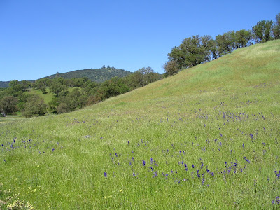
Once you’re back down, the South Fork of Orestimba Creek begins to pick up through rolling oak-studded grasslands carpeted with a profusion of wildflowers in what is probably the best wildflower season in decades. It becomes an absolutely charming and very remote feeling place. You wonder, what is there to get excited about over this ditch? Some ditch.
.jpg)
The creek expands, winds, collects in crystal aqua blue pools at the base of lichen-crusted rocks, then shoots through a channel in sing-song motion. Birds are serenading at every turn. Some even chaperoned.

The sun is pounding, but it’s such a perfect temperature, you don’t even realize how debilitating it is and will be in a few hours when you’ve got to haul your sorry, tired, sun-stroked ass back the 20 miles you came in on so gleefully. Such a different experience from last time!
.jpg)
But for now, you’re just soaking, naked as the jaybird screeching in the tree above, in one of those exotic pools, the day is pure green and blue, dragonflies are abuzz, glittering like small airborne gemstones, a turtle plops into the creek, a hawk swoops down, and no day could be prettier or more tranquil, no place more beautiful.
And you’re the only person on earth.
Beyond the lovely creek bed, at mile 18 you come to a juncture taking you to Paradise Flat – a humongous meadow stretching out infinitely in all directions. Just a stunning sight, with big ridges dominating all views.
.jpg)
Then it’s on to Paradise Lake, where you feel like you’re farther in than if you were at the John Muir. Seriously. It’s almost scary, a bit unnerving, because at this point, you’ve worked your ass off, you’ve come 8 tough, tough miles from the Orestimba Corral, in your Tevas, fording the creek over a dozen times.

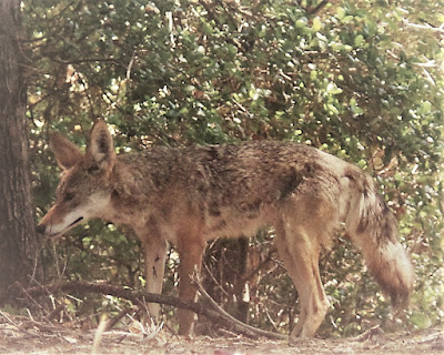
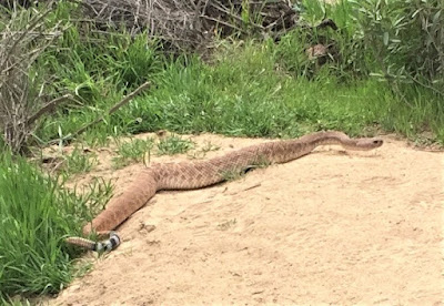
Sometimes even storming across on the bike, but mostly getting off and carrying it across deeper pools. The trail is the creek bed; the creek bed is the trail. You look down and see a long trail of deer prints, alternating with mountain lion prints.

You're getting a bit spooked by now.
You go on.
At this point, you’re worn out, you haven’t eaten all that much, and, of course, you’re underhydrated. What an idiot, you’re thinking. You’ve forgotten your sunblock, didn’t bring your water filter, have no first aid kit, nothing to keep you warm. You’re not 27 anymore, fer chrissakes, not even 39 – you’re four months shy of the big FIVE-O!

Anything could happen.
But today you’re lucky – nothing really happens except paranoia in your mind, a minor panic attack, nothing that an icy dip in the lake can’t cure. So you sigh deeply, check out the position of the sun, guess it’s about 3:30, you’re thoroughly amazed that you’ve spent so much time in the back country already, and how quickly it passes, so suck it up, bud, and get back in the saddle for the 20-mile haul back.
.jpg)
You can do it! And you did!
posted by Gambolin' Man at Thursday, August 25, 2005
2 comments
![]()

