MARIN COUNTY OPEN SPACE DISTRICT: Hiking the Twisty Mile-Long Cascade Creek Trail to the "Inkwells" in the Upper Reaches of the Mount Tamalpais Watershed
.jpg)
On the heels of a few inches of much-needed rain, I eagerly anticipated – make that thirsted for – the soul-quenching sight of bone-dry gullies, ravines and creek beds resuscitating to life with the sparkling flow of precious run-off.
.jpg)
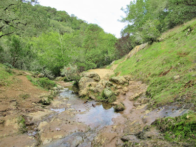
And what better place to experience hydrologic renewal than at one of Mount Tamalpais' loveliest coast range streams – Cascade Creek – located in Marin County Open Space District lands outside the fair town of Fairfax, California.
Mother Earth, though, has been so parched that most of the water was just soaked up by a rock-hard sponge leaving little to no runoff or ephemeral flows at best.

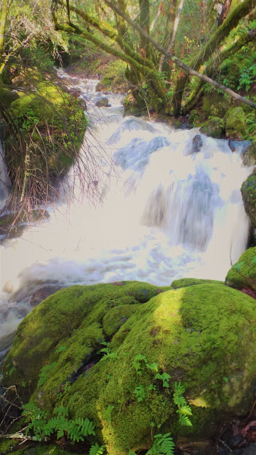
But it rained in the North Bay a bit harder and just enough for Marin's deep drainages to fill subterranean aquifers and allow Cascade Creek to flow uninterruptedly, albeit still modestly, in higher elevations.
.jpg)
In the bottomlands, at 200 ft., the wider scoured out channel of San Anselmo Creek remains a fossilized remnant of its glorious gushing potential, at least until the next predicted phase of "bad weather" creates more thunderstorms to replenish its dry rocky bed.
.jpg)
It's amazing how a few raindrops from the heavens can transform months of dry, dusty trails, cloaking haze and choking heat into a moist, fresh paradise reminiscent of a real temperate rainforest, aromatic of sensual earthy smells, daubed with a palette of shimmering autumnal colors that lend the forest a quaint, almost "back East" look and feel.
.jpg)
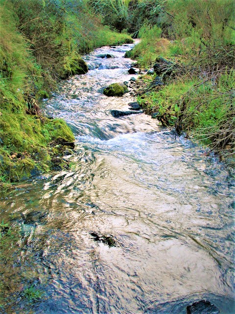
At its lower juncture with San Anselmo Creek, Cascade Creek disappears underground (for now), but still packs plenty of H2O discharge from its high, mysterious origins to burble merrily along through a fern-choked riparian corridor with an aquatic sort of bonhomie that veritably jumpstarts the crackling, brittle forest to palpable life.
.jpg)
As such, harmonizing frequencies with its once-vanquished melodies of water, now unbridled, sing-songing through carved flutes, and swirling in and out of channels in a rhythmic motion that mesmerizes and enchants at every nook and bend.
.jpg)
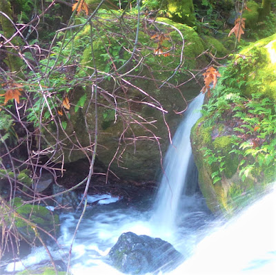
The soothing water gathers in modest pools, where soon young trout will come swimming up to seek their rearing habitat – the best to be found in the 28 square mile Corte Madera Creek Watershed.
.jpg)
Now, there are only a few shallow pools under shady canopy harboring survivor populations of steelhead (rainbow trout). The more suitable (soon to be) gravelly spawning grounds are downstream.
.jpg)
There, the steelhead will construct their nests (redds) to hatch the next generation of these magnificent fish making a huge comeback thanks to sustained efforts of groups like Friends of Corte Madera Creek Watershed.
.jpg)
Thirty-six years ago, in the galvanizing spirit of newly anointed Earth Day, the Marin County Open Space District became a reality.
.jpg)
Voters, leery of anti-environmental development / expansion mentality of the 1970s, which favored unchecked highway, mall and housing construction on Marin's "underutilized", "empty" and otherwise financially unexploited ridges and open spaces, ultimately approved the agency's mandate to acquire and manage the county’s outstanding lands not already under State and Federal Park supervision.
.jpg)
And what Super Vision!
These islands of biological, hydrological, ecological, geological, archaeological, aesthetic, and recreational significance include tiny parcels to larger spreads of priceless natural gems of open space such as Mount Burdell, Rush Creek, Blithedale Ridge, White Hill, Cascade Canyon, Gary Giacomini, and Roy's Redwoods.
.jpg)
The Marin County Open Space District today encompasses 14,675 acres, 34 preserves, and 175 miles of trails for unlimited recreational opportunities that include hiking, mountain biking, horseback riding, bird watching, you name it and they're probably doing it (illegal or not).
.jpg)
The open space preserves also provide habitat for many animals; within its purlieus, several species have been identified as sensitive, including Northern spotted owl, winter-run steelhead, Cooper's hawk, white-tailed kite, horned lark, wrentit, and the common poorwill. (No sightings of red-legged frogs observed.)
.jpg)
Colorful displays of poppies, lupines, clarkia, checkerbloom, fiddleneck, tarweed, soap plant, and clovers dot the grassy slopes of hills and meadows in spring, bringing out legions of photographers, botanists, water colorists, and casual admirers.
.jpg)
Outstanding among all these protected lands is Cascade Canyon Open Space Preserve, designated a "sensitive wildlife area” encompassing 500 acres of oak and mixed hardwoods, grasslands, chaparral, and riparian corridor.
.jpg)
This pristine land – drained by three streams (San Anselmo Creek, Cascade Creek, and Carey Camp Creek) – provides recreational opportunities galore for Marin's (and the rest of the Bay Area) outdoorsy nature lovers.
.jpg)
It's also a beloved haven for urban escapees seeking respite from heat and crowds, an irenic redoubt of sylvan and riparian charm, big inspirational views, and excellent birding.
.jpg)
The preserve is a quick and simple get-away to a magical, easy-going place – but it's been so heavily impacted by untold thousands over the years that no wonder MCOSD had to commission a Land Management Plan (LMP) to lay out the conflicting environmental problems and use issues.
.jpg)
They were forced to propose recommendations for mitigating many of the adverse impacts, among them illegally built mountain bike trails, dogs roaming off leash disturbing wildlife, soil erosion and sedimentation affecting deteriorating water quality, sudden oak death syndrome, maybe even the sky falling.
.jpg)
Naturally, existing on the fringes of a populated area, this special place is bound to be a magnet for bikers and hikers and their dogs, most of whom, according to the report, are in violation of MCOSD regulations requiring dogs to be leashed.
.jpg)
But what the hell, this is Marin County!
.jpg)
And Marinites are not ones to obey imposed (and perceived “draconian”) laws when it comes to THEIR recreational turf and activities.
.jpg)
To wit, dozens of scofflaw mountain bikers, dozens of infractions to owners who disregard the rules and let their dogs run off-leash. I suspect the majority of dogs are under voice control and are well-behaved (I assume the same about their owners), and I doubt many are running up and down hillsides off the fire roads terrorizing wildlife.
.jpg)
.jpg)
I should know, I'm a mountain biker as well as a feet-to-the-earth guy.
Putting aside land use controversies, it's plain that most visitors to the preserve are in and out pretty quickly for a leisurely stroll along the creek to take in the premier sight of Cascade Falls – that is, when it's flowing forcefully, which is the heavy use period between now and April.
.jpg)
Most people don't seem overly interested in "less spectacular" flows of water, like now, whereas Gambolin' Man is inordinately charmed by any amount of water flowing over bedrock and considers it no small miracle, however dramatic or mundane be the flow.
So, we don't see too many people heading out to Cascade Falls, despite it being a beautiful rain freshened day, with subtle lighting enhancing every natural detail.
.jpg)
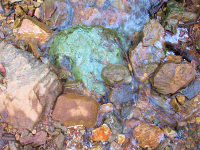
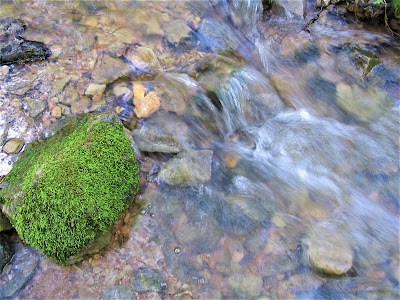
Phosphorescent green moss carpeting trees and rocks, tiny ferns dancing the hula atop a boulder, bizarrely patterned shelf mushrooms thriving on a rotted log, richly yellow leaves layered like an artistic creation of Andy Goldsworthy, deeply textured, magnificently colored red and blue creek rocks.
.jpg)
Each visit to Cascade Canyon Open Space Preserve enthralls evermore with the little things and sights along the way, that hiking becomes second to just enjoying the enraptured moment.
.jpg)
On each successive visit to the preserve, the surroundings seem more and more expansive, for there's always a new trail to explore, a different direction to set off, where, eventually, if you hike long and far and high enough, all things connect up to Big Carson, Pine Mountain, and Blue Ridges, on Mount Tamalpais' rolling flanks.
.jpg)
Up here, you’re seemingly on top of the world, where you can gaze out in wonder at the sheer wildness in every direction and realize you could spend a lifetime exploring and having fun in these protected lands – Mount Tamalpais State Park, Marin Municipal Water District, Mount Tamalpais Watershed, and the surrounding open space preserves.
.jpg)
Little wonder that Marin County is one of the most expensive places in the Bay Area – and the nation – to live. On this gorgeous fall day, we find ourselves lingering at Cascade Falls.
.jpg)
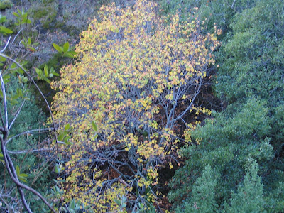
We're spellbound in motionless splendor watching golden-red big leaf maple leaves flutter down dancing with gravity to gently land in splotches of water and gather in artistic polychrome piles or be carried away on a rafting journey downstream.
.jpg)
We're listening to the sounds of the forest, of unseen birds chirping, of hidden frogs croaking, of water pouring over lip of rock to shallow pool.
.jpg)
If you've ever stood here on the lookout rock facing the cascade when it’s crashing, you know it’s a magical sight, but now, itching to get some exercise, and with the high trail above beckoning for an adventurous scramble-ramble, we climb up and over the falls – easy to cross – and set off up canyon to see where it takes us.
.jpg)
From this point on, Cascade Creek Trail becomes a narrow, twisting path that we track for a scruffy mile and a tough climb of 700 ft. (to an elevation of 1200 ft.) as it contours along the eastern side of Cascade Creek.
.jpg)
In short time, after a lung-busting strut up a steep ass section of fractured chocolate colored Franciscan Formation rocky trail, we come to a beautiful lookout point.
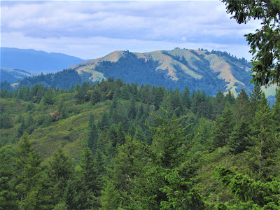
.jpg)
We stop to take in the majestic view of Mount Tamalpais' 2571 ft. East Peak busting through cloud cover to the southeast, and visions of gigantic rock outcrop dotted forested and chaparral foothills rising up all around as though we’re in big North Fork country or somewhere more exotic than our local hiking spot.
.jpg)
This lookout point is as far as we'd made it last time, opting then to instead bushwhack up and down the creek boulder hopping in playful abandon like little kids.
Further on, the trail becomes "non-recognized” by the MCOSD LMP which wishes to discourage and make trespassing illegal along this trail.
.jpg)
That's because of its passage through sensitive ecology – but so far, three years after the last LMP update of 2005, no signs have been posted or fences erected, so presumably, it’s still legit to make the traverse up to the hitherto unknown about Inkwells.
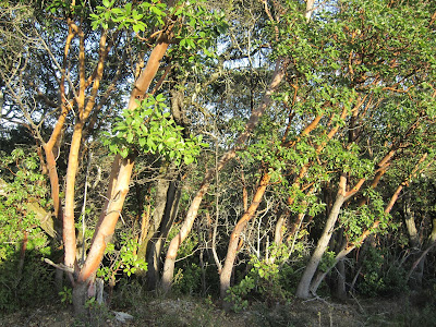
The snaky, unstable in places trail winds through a beautiful mixed forest of coast live oak, California black oak, occasional tanbark oak, scattered blue oak, and buckeye, bay, madrone, manzanita, and bigleaf maple. It eventually connects up to Big Carson Ridge high above at 1500 ft.

This dense thicket of a hike on taut singletrack forces you to squeeze through overgrown brush and duck under fallen canopy and cling to manzanita branches to assist in passage over unstable drop-offs. You’re covered in sweat, spider webs and sweet-smelling debris.

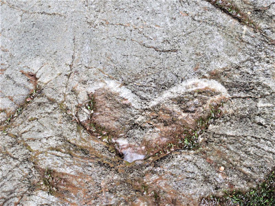
Then suddenly the view opens up in an amphitheater like bowl with high unattainable ridges, eroded outcroppings, and down below Cascade Creek cutting a singular channel through it all emanating from a mini-gorge / waterfall creating two nice dipping pools – the Inkwells.
.jpg)
It’s a real holy-shit moment of revelatory surprise and uncontained joy to see a Mount Diablo or Mount Saint Helena like sight right here in the upper reaches of Cascade Canyon.
According to the LMP, the aptly named Inkwells is a "popular" haunt of locals who no doubt wish to keep it a secretive location.
.jpg)
Well, believe Gambolin' Man when he says you gotta be in the know, because it's not an easy or intuitive place to find or get to. You will not see it marked on any map or mentioned in any guidebook.
A quick Google search turns up nothing on it, except another locale on San Geronimo Creek off Sir Francis Drake Boulevard called the Inkwells.

I've been to those Inkwells (didn't know they were named as such), and they're pretty nice dipping holes, but given their extreme propinquity to easy access, it's a huge party hang chill scene for local teens and twenty somethings.
.jpg)
But these Inkwells – well, let's just say I'd never even heard of them until, pushed on by an inexorable urge to see what could be around the next bend, I "discovered" the place and was completely taken aback by the sight of such an unexpected natural wonder.
It's not that the Inkwells are so geologically spectacular or represent some kind of unique land formation per se.
It's just that after bushin' through dense forests high above the creek with no end in sight, they burst upon the scene so unexpectedly and stand out so dramatically from the typical riparian landscape that their existence can only be called fantastical.
.jpg)
All alone in this big world, we scramble along a barely maintained, eroded trail over to the grotto-like formation. It’s a very pretty scene even with just minimal water flowing over the rock lips. On the north slope, a dry cascade at least 500 ft. high runs the length of a gully and joins the creek just before a plunge pool.
Can't wait to see that amazing sight during super run-off! But it will run off ever so quickly so to appreciate its full power will require being there immediately after the downpour, or during, a tough prospect to tackle! (Kinda like Murietta Falls in the Ohlone Wilderness.)
The Inkwells are intriguing and leave us marveling at their etched beauty, but it's hard to not imagine how much more impressive the sight will be once the creek is really gushing and turns this rugged and wild place into a raucous tumbler.
Enjoy the moment, Gambolin' Man, enjoy the precious moment!
.jpg)
.jpg)
That's the magic of Bay Area Wild – no shortage of that!
But now, alas, it’s getting late (and it’s only 4 pm) so we'd best be making good time back the way we came.
.jpg)
We’ll leave the connector trail, picking up above the Inkwells and heading up to the ridge top Cascade Canyon fire road – aka Repack – for our next ever more expansive outing in this wondrous land of perennial surprises.
.jpg)
Read more Gambolin' Man write-ups about incredible, fabulous, amazing Marin County:
.jpg)
Read more posts from Gambolin' Man on Marin County's incomparable and magnificent Point Reyes National Seashore:
Take a moment to enjoy some live-action scenes taken in Marin County's Open Space District lands & various other stunningly beautiful Marin County locales @
posted by Gambolin' Man at Thursday, November 13, 2008
3 comments
![]()

