STEBBINS COLD CANYON RESERVE: Exploring a Little-Known Gem in the Vaca Mountains of the North Coast Range
.jpg)
Uh, say where?!
.jpg)
How did such a jewel of nature ever escape my attention right in my own back yard?!
.jpg)
And yet Cold Canyon has indeed remained unknown about and undiscovered until now . . . despite nearly a quarter century of seeking out new sights and exploring the varied wonders of nature in the greater Bay Area.
How is it that not once did I think to give this area – the lower watershed lands of Putah Creek – even so much as a passing glance? Well, one look at the utterly nondescript map and it was obvious that nothing of any possible interest or appeal could be found there, right?
.jpg)
Plus, it just goes to show you how much there is to see and do locally / regionally. (Twenty-five more years may pass, and may I still be discovering new places!) Finally, stop mistaking the map for the territory!
.jpg)
Cold Canyon and the Vaca Mountains are situated in the southern and eastern most ridges of the North Coast Range, where it sort of peters out a bit north of the delta lands of our great bay system.
.jpg)
How many times had I zipped by there and looked out at that Big West ridge extending far north like a monstrous spine, wondering what lay beyond?
.jpg)
Certainly, I had explored the Cache Creek wilderness farther north in Lake County (sister watershed to Putah) – but figured there wasn’t much really going on in the lowly “Cow” mountains.
.jpg)
After all, I-80 and the bustling suburban sprawl of Fairfield and Vacaville were situated so damn close! I had always mistakenly aligned this area more with the Diablo Range.
.jpg)
But it is an ecologically and geologically distinct zone replete with unique flora of varied plant communities well adapted to a drier climate, and a wide-ranging fauna.
Along with its rugged geology, and human history of the Southern Patwin inhabiting the region as far back as 4,000 years, Cold Canyon turns out to be one fascinating place I’ll always return to. And it will always be there to return to, because it is one of 26 University of California natural reserves.
.jpg)
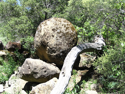
Cold Canyon has been around in its present incarnation for nearly a million years. It is a geologically dynamic area created out of vast and imponderable forces of an earth in upheaval, eroding and depositing layers of sediment over untold millions of years.
.jpg)
Followed by more catastrophic continental uplift, more erosion, and voila, you have Cold Canyon. These profound geologic processes are active to this day, continuing to shape the canyon in ways we can only surmise.
.jpg)
Cold Canyon’s vegetation is healthy, rich and diverse, with several plant communities dominating and interspersing – savanna, grassland, riparian woodland, live oak woodland, and chaparral.
.jpg)
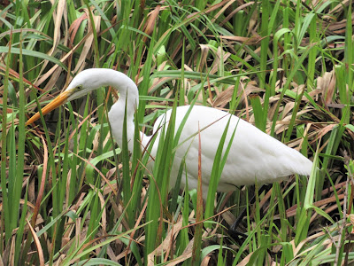
Big leaf maples, cottonwoods, blue oak, interior live oak, manzanita, buck brush, foothill pines, willow trees, California bay, Western redbud, and the thickly blooming buckeye populate the canyon with lovely specimens, providing habitat for Black Phoebes, wren-tits and bushtits, Spotted Towhee and assorted hummingbirds, sparrows and warblers.
And so on a hot Spring day, we set off on Homestead Trail, an easy one-mile hike along the lower reaches of Cold Creek just before it spills into Putah Creek. I grab a pamphlet, Hiking in Stebbins Cold Canyon Reserve, which serves as an interpretative guide for 32 markers of interest. We would save the high ridge loop hike for another time.
.jpg)
Marker #1: Outlet of Cold Creek, points out that just upstream is a spawning area for wild trout.
Marker #6: Landslide, informs us of the major earth movement in 1995.
Marker #24: Bedrock Underlying Cold Creek, refers to the shale bedrock and grey layers of the Yolo formation.
Marker #6: Landslide, informs us of the major earth movement in 1995.
Marker #24: Bedrock Underlying Cold Creek, refers to the shale bedrock and grey layers of the Yolo formation.
Marker #30: near the end, deep in a shaded forest well above the creek, is "Homestead", the only remnant of the Vlahos' former farmhouse built in the thirties. All in all, an edifying, easy and leisurely stroll, and, surprisingly, not many people at all.
.jpg)
But now, I suggest, let’s delve deeper into the higher reaches of the canyon, where the stream flows gloriously through big, remote hill country, and where I suspect we will find lovely little dipping pools amid stunning bird watching and riparian landscapes.
.jpg)
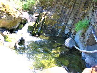
Marker #22: Cold Creek, we learn about a variety of flora on display along the banks of the seven-month "live" creek. There, we duck off the path and begin our rock hop escapade a thousand yards up to higher elevations.
.jpg)
Cold Creek flows magically through these enchanting canyon stretches, originating from springs deep within the big hills looming due north. No, "it ain't the North Fork" nor is it any number of other more grandiose streams of wild California; what it is, though, is what it is.
.jpg)
And that would be sweet, charming, beautiful, and flat-out gorgeous. If I never had another stream to explore, dip in, or meditate by, I wouldn’t care . . . of course, I say that about nearly every stream I know.
.jpg)
We hop, prance and cavort from boulder to boulder, occasionally splashing through the water or following a deer path along the side. We check out the water striders, and see a few frogs, a snake, many lizards and tons of glittering multi-colored dragonflies.
.jpg)
It is a world plush with life, most of it unseen. The brush becomes thick in places, and we have to crawl, twist, bend, duck, curl and do the limbo to get to our destination – a small but adequate and extremely pretty pool / waterfall scene of exposed vertical rock presided over by a pleasant and shady cottonwood tree.
.jpg)
The water is perfect on this hot day. The view of the big peak on the far ridge highlights the sense of remote and splendid isolation we find ourselves in.
.jpg)
The trail is now high above us. Although there is carved evidence of people having made it here, it seems apparent that only a rare hiker would engage in the effort to get so far upstream from the trail marker. Mary and I test this theory out by making love right then and there, and most certainly in this case practice proves theory absolutely correct.
.jpg)
I leave Mary to her whiles and whimsical thoughts and go exploring farther upstream. I can’t help it, I always have to explore farther upstream. The creek narrows, then opens up, flowing swiftly through channeled rocks in perfect little zen gardens, riotous with wildflowers and other plants I don’t recognize lining the banks.
.jpg)
I push it higher, harder, farther, pouncing and bouncing from one rock to the next, jumping over pools, and stopping often to just stare and appreciate the wildness of where I was – lost in Cold Canyon, vulnerable to the ravages of nature, lunchmeat perhaps for a mountain lion.
.jpg)
Nothing of the sort. Just clear flowing water and birdsong, whispering breezes and humming insects, all music to my ears and soul. Just tremendous views of Blue Ridge and Pleasants Ridge, and not a shred of evidence that any human has ever been here.
.jpg)
I hoped to reach Wildhorse Canyon, but don’t make it, instead beating a hasty retreat to where I left Mary, at our sacred and secret site. She admits to being spooked and hallucinating meowing lionesses creeping up on her.
.jpg)
We kick back for several more hours at our lovely spot in the upper reaches of Cold Canyon, wishing that all of our friends could be here with us, to see and appreciate the simple wonders of this precious canyon that we’ve just begun to know and explore.
posted by Gambolin' Man at Sunday, May 29, 2005
![]()


3 Comments:
We hiked the other end of the Cold Canyon Reserve Loop Trail straight up to the ridgetop. In mid-April we found lots of wildflowers blooming, but the buckeyes were not yet blooming. I'll have to make another trip later in the season to see them.
Stebbins Cold Canyon trip report - maps, hiking, wildflowers & photos - 10april2010.
I have lived in Yolo county most of my life, and this area is not unfamiliar to me. I have one question that no one can seem to answer however. Where does Cold Creek come from? Is there a small natural collecting pond? I've been up there hiking around in summer when the creek is sparse, but it still flows.
Thank you for any answers you can provide.
Lighthouse 9
Lighthouse 9 - my guess is that the upper reaches have subterranean bedrock cisterns which captures run-off and holds it indefinitely, gradually releasing its contents throughout the year.
Post a Comment
<< Home